Alliance, Nebraska | |
|---|---|
 Downtown Alliance: Box Butte Avenue | |
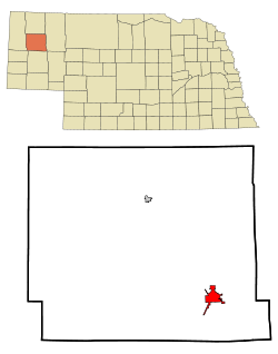
 Location of Alliance within Nebraska and Box Butte County | |
| Coordinates: 42°06′11″N 102°52′36″W / 42.10306°N 102.87667°W | |
| Country | United States |
| State | Nebraska |
| County | Box Butte |
| Area | |
• Total | 4.91 sq mi (12.71 km2) |
| • Land | 4.89 sq mi (12.68 km2) |
| • Water | 0.01 sq mi (0.03 km2) |
| Elevation | 3,970 ft (1,210 m) |
| Population (2020) | |
• Total | 8,151 |
| • Density | 1,665.51/sq mi (643.05/km2) |
| Time zone | UTC−7 (Mountain (MST)) |
| • Summer (DST) | UTC−6 (MDT) |
| ZIP code | 69301 |
| Area code | 308 |
| FIPS code | 31-00905 |
| GNIS feature ID | 2393923[2] |
| Website | cityofalliance.net |
Alliance is a city and the county seat of Box Butte County,[3] in the western part of the state of Nebraska, in the Great Plains region of the United States. Its population was 8,151 at the 2020 census.[4]
Alliance is home to Carhenge, a replica of Stonehenge constructed with automobiles, which is located north of the city. It is also the location of Alliance Municipal Airport, the least-used airport in the mainland United States.
- ^ "ArcGIS REST Services Directory". United States Census Bureau. Retrieved September 18, 2022.
- ^ a b "City of Alliance". Geographic Names Information System. United States Geological Survey, United States Department of the Interior. Retrieved December 11, 2023.
- ^ "Find a County". National Association of Counties. Archived from the original on May 31, 2011. Retrieved June 7, 2011.
- ^ "U.S. Census Bureau QuickFacts: Alliance city, Nebraska". United States Census Bureau. Retrieved May 21, 2021.