| Allier | |
|---|---|
 Bridge over the Allier in Brioude, Haute-Loire. | |
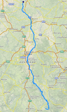
 Map of the Allier in France [1] | |
| Native name | Alèir (Occitan) |
| Location | |
| Country | France |
| Physical characteristics | |
| Source | Moure de la Gardille, Margeride |
| • location | Massif Central |
| • coordinates | 44°35′23″N 3°48′04″E / 44.58972°N 3.80111°E |
| • elevation | 1,503 m (4,931 ft) |
| Mouth | |
• location | Loire (bec d'Allier, Cuffy/Gimouille) |
• coordinates | 46°57′34″N 3°4′44″E / 46.95944°N 3.07889°E |
• elevation | 167 m (548 ft) |
| Length | 421 km (262 mi) |
| Basin size | 14,350 km2 (5,540 sq mi) |
| Discharge | |
| • average | 140 m3/s (4,900 cu ft/s) |
| Basin features | |
| Progression | Loire→ Atlantic Ocean |
 | |
The Allier (UK: /ˈælieɪ/ AL-ee-ay,[1] US: /ælˈjeɪ, ɑːlˈjeɪ/ a(h)l-YAY,[2][3] French: [alje] ; Occitan: Alèir) is a river in central France. It is a left tributary of the Loire. Its source is in the Massif Central, in the Lozère department, east of Mende. It flows generally north. It joins the Loire west of the city of Nevers. It is 421 km (262 mi) long, and has a drainage basin of 14,350 km2 (5,540 sq mi).[4]
- ^ "Allier". Lexico UK English Dictionary. Oxford University Press. Archived from the original on 2019-12-29.
- ^ "Allier". Collins English Dictionary. HarperCollins. Retrieved 21 August 2019.
- ^ "Allier". Merriam-Webster.com Dictionary. Merriam-Webster.
- ^ Sandre. "Fiche cours d'eau (K---0080)".