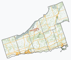
Alnwick/Haldimand | |
|---|---|
| Township of Alnwick/Haldimand | |
 Township hall in Grafton | |
| Nickname: The Township between the Lakes | |
| Coordinates: 44°05′N 78°02′W / 44.083°N 78.033°W | |
| Country | Canada |
| Province | Ontario |
| County | Northumberland |
| Incorporated | 2000 |
| Government | |
| • Type | Township |
| • Mayor | John Logel |
| • Federal riding | Northumberland-Peterborough South |
| • Prov. riding | Northumberland—Peterborough South |
| Area | |
| • Land | 398.25 km2 (153.77 sq mi) |
| Population (2021)[1] | |
• Total | 7,473 |
| • Density | 18.8/km2 (49/sq mi) |
| Time zone | UTC-5 (EST) |
| • Summer (DST) | UTC-4 (EDT) |
| Postal Code | K0K |
| Area codes | 905, 289, 365, and 705 |
| Website | www |
The Township of Alnwick/Haldimand is a township in central Ontario, Canada, in Northumberland County, situated between Lake Ontario and Rice Lake. It was formed in 2001 by the merger of Alnwick Township in the north and Haldimand Township in the south.[2] Alderville First Nation is an autonomously governed First Nation contained within the township boundaries, in two non-contiguous sections along County Roads 45 and 18.
- ^ a b "Alnwick/Haldimand (Code 3514024) Census Profile". 2021 census. Government of Canada - Statistics Canada. Retrieved 2024-10-04.
- ^ "Municipal Restructuring Activity Summary Table". www.mah.gov.on.ca. Archived from the original on 2014-03-08. Retrieved 2015-08-16.

