Alstahaug Municipality
Alstahaug kommune | |
|---|---|
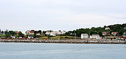
 Village of Tjøtta in Alstahaug | |
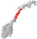
 Nordland within Norway | |
 Alstahaug within Nordland | |
| Coordinates: 65°57′24″N 12°34′22″E / 65.95667°N 12.57278°E | |
| Country | Norway |
| County | Nordland |
| District | Helgeland |
| Established | 1 Jan 1838 |
| • Created as | Formannskapsdistrikt |
| Administrative centre | Sandnessjøen |
| Government | |
| • Mayor (2019) | Peder Talseth (Sp) |
| Area | |
• Total | 188.16 km2 (72.65 sq mi) |
| • Land | 187.20 km2 (72.28 sq mi) |
| • Water | 0.96 km2 (0.37 sq mi) 0.5% |
| • Rank | #308 in Norway |
| Highest elevation | 1,072.01 m (3,517.09 ft) |
| Population (2024) | |
• Total | 7,421 |
| • Rank | #137 in Norway |
| • Density | 39.4/km2 (102/sq mi) |
| • Change (10 years) | |
| Demonym | Alstahaugværing[2] |
| Official language | |
| • Norwegian form | Neutral |
| Time zone | UTC+01:00 (CET) |
| • Summer (DST) | UTC+02:00 (CEST) |
| ISO 3166 code | NO-1820[4] |
| Website | Official website |
Alstahaug is a municipality in Nordland county, Norway. It is part of the Helgeland region. The administrative centre of the municipality is the town of Sandnessjøen. Some of the villages in Alstahaug include Søvika and Tjøtta.


Most residents of Alstahaug live in the town of Sandnessjøen which is situated on the island of Alsta. The characteristic Seven Sisters mountain range is found on the eastern part of the island. Local legend has made this chain of peaks into seven sisters, two adjacent peaks representing twin sisters.
The island is connected to the mainland via the large Helgeland Bridge along Norwegian County Road 17. The Sandnessjøen Airport, Stokka is located 10 kilometres (6.2 mi) south of Sandnessjøen.
The 188-square-kilometre (73 sq mi) municipality is the 308th largest by area out of the 357 municipalities in Norway. Alstahaug is the 137th most populous municipality in Norway with a population of 7,421. The municipality's population density is 39.4 inhabitants per square kilometre (102/sq mi) and its population has increased by 0.4% over the previous 10-year period.[5][6]
- ^ "Høgaste fjelltopp i kvar kommune" (in Norwegian). Kartverket. 16 January 2024.
- ^ "Navn på steder og personer: Innbyggjarnamn" (in Norwegian). Språkrådet.
- ^ "Forskrift om målvedtak i kommunar og fylkeskommunar" (in Norwegian). Lovdata.no.
- ^ Bolstad, Erik; Thorsnæs, Geir, eds. (26 January 2023). "Kommunenummer". Store norske leksikon (in Norwegian). Kunnskapsforlaget.
- ^ Statistisk sentralbyrå. "Table: 06913: Population 1 January and population changes during the calendar year (M)" (in Norwegian).
- ^ Statistisk sentralbyrå. "09280: Area of land and fresh water (km²) (M)" (in Norwegian).

