| Coat of Arms | Map |
|---|---|
 Seal of 1280 |
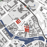
 Alt-Berlin within Berlin's city center |
| Basic Information | |
| City: | Berlin |
| Borough: | Mitte |
| Locality: | Mitte |
| Coordinates: | 52°31′05″N 13°24′34″E / 52.51806°N 13.40944°E |
| Elevation: | 34 m (111 ft) above sea level |

Alt-Berlin ("Old Berlin"), also spelled Altberlin, is a neighborhood (Stadtviertel), situated in the Berliner locality (Ortsteil) of Mitte, part of the homonymous borough. In the 13th century it was the sister town of the old Cölln, located on the northern Spree Island in the Margraviate of Brandenburg. The neighbourhoods (Viertel) of Nikolaiviertel, Marienviertel, Klosterviertel are within Alt-Berlin.[1]
- ^ Ralph Hoppe. "Das Klosterviertel - Zu unrecht wenig beachtet". StattReisen Berlin. StattReisen Berlin. Retrieved 2023-04-25.