| Alta Mountain | |
|---|---|
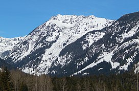
 Alta Mountain seen from Interstate 90 at Hyak | |
| Highest point | |
| Elevation | 6,275 ft (1,913 m)[1] |
| Prominence | 585 ft (178 m)[1] |
| Parent peak | Hibox Mountain (6,550 ft)[1] |
| Isolation | 1.59 mi (2.56 km)[1] |
| Coordinates | 47°26′28″N 121°19′55″W / 47.441131°N 121.331964°W[2] |
| Geography | |
| Country | United States |
| State | Washington |
| County | Kittitas |
| Protected area | Alpine Lakes Wilderness[2] |
| Parent range | Cascade Range |
| Topo map | USGS Chikamin Peak |
| Climbing | |
| Easiest route | Scrambling (class 2) South Ridge |
Alta Mountain is a 6,275-foot (1,913-metre) mountain summit located in Kittitas County of Washington state.[3] It is set within the Alpine Lakes Wilderness which is part of the Cascade Range.[2] Alta Mountain is situated on land managed by Wenatchee National Forest. Precipitation runoff from the mountain drains into tributaries of the Yakima River.
- ^ a b c d "Alta Mountain - 6,275' WA". listsofjohn.com. Retrieved 2024-04-09.
- ^ a b c "Alta Mountain, Washington". Peakbagger.com.
- ^ "Alta Mountain". Geographic Names Information System. United States Geological Survey, United States Department of the Interior. Retrieved 2018-07-26.

