| Altar Valley | |
|---|---|
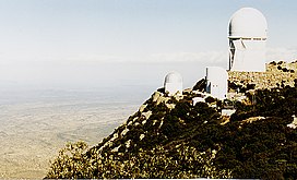
 Typical Sonoran Desert bajada lands (from Kitt Peak, Quinlan Mountains, NW valley) | |
| Length | 45 mi (72 km) |
| Geography | |
| Population centers | Robles Junction, AZ-N Sasabe, AZ-S |
| Borders on | Quinlan Mountains-NW Baboquivari Mountains-SW |
| Coordinates | 31°49′N 111°24′W / 31.82°N 111.40°W |
The Altar Valley is a 45-mile (72 km) long north–south valley, trending slightly northeast from Sasabe, Arizona on the Mexico border to the Avra Valley west of the Tucson Mountains. It is delimited by Arizona State Route 86, from east-to-west on the north separating it from the Avra Valley which then trends northwesterly, merging into the plains and drainage of the Santa Cruz River.
The valley is traversed from north to south by Arizona Route 286.
The major Baboquivari sky island range borders the valley on the west; the east is bordered by a series of mountain ranges, that have Nogales, Arizona nestled in between at the United States-Mexico border. Two wilderness areas lie to the west of the valley, the Coyote Mountains Wilderness east of Kitt Peak Observatory, and the Baboquivari Peak Wilderness.
The center of the valley is near Baldy Peak (31°50′46″N 111°20′06″W / 31.8462°N 111.3351°W) in the southwest Sierrita Mountains.[1] Baldy Peak's height is 4,120 feet (1,256 m).[2]
- ^ Trails Near Baldy Peak
- ^ Arizona Road & Recreation Atlas, pp. 86–87.
