This article has multiple issues. Please help improve it or discuss these issues on the talk page. (Learn how and when to remove these messages)
|
| Amaravathi River Aanporunai | |
|---|---|
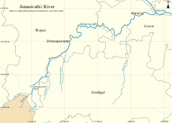
 River Amaravathi and its tributaries | |
 | |
| Etymology | from Purananuru 36 |
| Location | |
| Country | India |
| Location | Udumalaipettai- Dharapuram-Aravakurichi-Karur, Tamil Nadu |
| Physical characteristics | |
| Source | |
| • location | Anamalai Hills, Chinnar River, Pambar River at |
| • coordinates | 10°21′2″N 77°14′14″E / 10.35056°N 77.23722°E |
| • elevation | 473 meters (1,552 ft) |
| Mouth | |
• location | Karur at |
• coordinates | 10°57′36″N 78°4′53″E / 10.96000°N 78.08139°E |
• elevation | 360 feet (110 m) |
| Length | 282 km (175 mi) |
| Basin size | 8,380 km2 (3,240 sq mi)[1] |
| Basin features | |
| River system | Kaveri |
| Tributaries | |
| • right | Nanganji, Kodavanar |
The Amaravati River is the longest tributary[citation needed] of the Kaveri River in the fertile districts of Udumalpet, Dharapuram and Karur Tamil Nadu state, South India.
- ^ "Integrated Hydrological Data Book" (PDF). India. p. 76. Archived from the original (PDF) on 20 May 2014. Retrieved 25 March 2014.