This article needs additional citations for verification. (June 2019) |
Ambedkar Nagar district | |
|---|---|
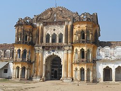
 Fort at Hanswar | |
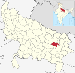
 Location of Ambedkar Nagar district in Uttar Pradesh | |
| Country | |
| State | Uttar Pradesh |
| Division | Ayodhya |
| Established | 29 September 1995 |
| Headquarters | Akbarpur |
| Tehsils | Akbarpur, Tanda, Jalalpur, Alapur, Bhiti |
| Government | |
| • Lok Sabha constituencies | 1. Ambedkar Nagar Lok Sabha constituency - Akbarpur, Jalalpur, Katehari, Tanda 2. Sant Kabir Nagar (Lok Sabha constituency) - Alapur |
| • Vidhan Sabha constituencies | 1. Katehari 2. Akbarpur 3. Tanda 4. Jalalpur 5. Alapur |
| • District Magistrate | Avinash Singh, IAS |
| • Superintendent of Police | Kaustubh, IPS |
| Area | |
• Total | 2,350 km2 (910 sq mi) |
| Population (2011) | |
• Total | 2,397,888 |
| • Density | 1,000/km2 (2,600/sq mi) |
| Demographics | |
| • Literacy | 74.37% |
| • Sex ratio | 976 |
| Time zone | UTC+05:30 (IST) |
| Vehicle registration | UP-45 |
| Major highways | NH 28, NH 128, NH 233A, NH 233B State Highway 30 (Uttar Pradesh) |
| Website | Official Website |
Ambedkar Nagar is one of the 75 districts of the Indian state of Uttar Pradesh. This district is a part of Ayodhya division in the Awadh region of the state. This district was established on 29 September 1995 by carving out parts of the erstwhile Faizabad district (now Ayodhya district).[1] It was created by the then Chief Minister Mayawati and named in memory of B. R. Ambedkar, who worked for the advancement of the depressed classes. The total area of Ambedkar Nagar district is 2350 Sq. Km.[2]
- ^ "History | Ambedkarnagar | India". Retrieved 3 October 2022.
- ^ "Ambedkarnagar | Birthplace Of Ram Manohar Lohiya | India". Retrieved 8 March 2021.