Amberley | |
|---|---|
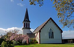
 Holy Innocent's Anglican Church, Amberley | |
 | |
| Coordinates: 43°9′20″S 172°43′50″E / 43.15556°S 172.73056°E | |
| Country | New Zealand |
| Region | Canterbury |
| Territorial authority | Hurunui District |
| Ward | South Ward |
| Electorates | |
| Government | |
| • Territorial Authority | Hurunui District Council |
| • Regional council | Environment Canterbury |
| • Mayor of Hurunui | Marie Black |
| • Kaikoura MP | Stuart Smith |
| • Te Tai Tonga MP | Tākuta Ferris |
| Area | |
| • Total | 3.70 km2 (1.43 sq mi) |
| Elevation | 50 m (160 ft) |
| Population (June 2024)[2] | |
| • Total | 2,770 |
| • Density | 750/km2 (1,900/sq mi) |
| Postcode | 7410 |
| Local iwi | Ngāi Tahu |
Amberley is a town located in the Hurunui District in north Canterbury, on the east coast of the South Island of New Zealand. It is located on State Highway 1 approximately 50 km north of Christchurch. It is the seat of the Hurunui District Council. The nearest town to the north of Amberly via state highway one is Waipara (11 km) and the nearest town to the south is Leithfield (5.7 km).
- ^ Cite error: The named reference
Areawas invoked but never defined (see the help page). - ^ "Aotearoa Data Explorer". Statistics New Zealand. Retrieved 26 October 2024.