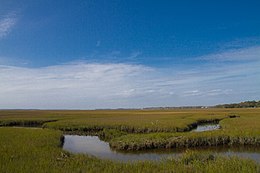
 Marshes surrounding Amelia Island | |
| Geography | |
|---|---|
| Location | North Atlantic |
| Coordinates | 30°36′56″N 81°27′14″W / 30.61556°N 81.45389°W |
| Length | 21 km (13 mi) |
| Width | 6.5 km (4.04 mi) |
| Administration | |
| Additional information | |
| Time zone | |
| • Summer (DST) | |
 | |
Amelia Island is a part of the Sea Islands chain that stretches along the East Coast of the United States from South Carolina to Florida; it is the southernmost of the Sea Islands, and the northernmost of the barrier islands on Florida's Atlantic coast.[1] Lying in Nassau County, Florida, it is 13 miles (21 km) long and approximately 4 miles (6.4 km) wide at its widest point. The communities of Fernandina Beach, Amelia City, and American Beach are located on the island.
- ^ Lionel Stevenson; Clyde de L. Ryals (1974). Nineteenth-century Literary Perspectives: Essays in Honor of Lionel Stevenson. Duke University Press. p. 22. ISBN 0-8223-0515-1.

