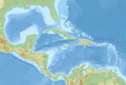
| American Mediterranean Sea | |
|---|---|
 Composite satellite image of the American Mediterranean Sea | |
| Location | The Americas |
| Coordinates | 18°N 80°W / 18°N 80°W |
| Type | Sea |
| Basin countries | List
|
| Surface area | 4,200,000 km2 (1,600,000 sq mi) |
| Average depth | 2,216 m (7,270 ft) |
| Max. depth | 7,686 m (25,217 ft) |
| Islands | 1100+ |
| Settlements | |
The American Mediterranean Sea is a scientific name for the mediterranean dilution basin which includes the Caribbean Sea and the Gulf of Mexico.[1]: 15, 35, 637–643 [2] The name, which has been employed particularly by German oceanographers, is not recognized by the USGS, the International Hydrographic Organization or other international hydrological bodies.[citation needed]
The American Mediterranean has a surface area of 4.319 million km2 and an average depth of 2,216 metres (7,270 ft).[1]
Its basins include the Mexico Basin, the Cayman Trough, the Yucatan Basin, the Columbian Basin, the Venezuelan basin and the Grenada basin.[3][1][4]
The American Mediterranean is considered one of the oceanic marginal seas. In addition to numerous small islands, large and small groups of islands, and islets, it includes the large islands of Cuba, bordering the Gulf of Mexico and the Caribbean; of Jamaica, Hispaniola, and of Puerto Rico. All of these islands are among the West Indian islands that separate the American Mediterranean from the Atlantic Ocean.
Between the islands, the American Mediterranean Sea contains the following straits: the Florida Straits, the Windward Passage (Paso de los Vientos), the Mona Passage (Canal de la Mona), the Anegada Passage to Guadeloupe Passage, the Dominica Passage to Martinique Passage, St. Lucia, and St. Vincent. Within the Mediterranean, the Straits of Yucatán to the Gulf of Mexico connect with the Caribbean, and by the Panama Canal, built in the 20th century, it is connected to the Pacific.
- ^ a b c Sverdrup, H. U.; Johnson, M. W.; Fleming, R. H. (1942). "The Oceans Their Physics, Chemistry, and General Biology, Chapter 15 The Adjacent Seas of the North Atlantic Ocean". University of California Press E-Books Collection. Retrieved 2022-05-04.
- ^ Tomczak, Matthias; Godfrey, J. Stuart (2013-10-22). Regional Oceanography: An Introduction. Elsevier. ISBN 978-1-4832-8761-4.
- ^ "Caribbean Sea | Definition, Location, Map, Islands, & Facts | Britannica". www.britannica.com. Retrieved 2022-05-04.
- ^ French, C. D, and C. J. Schenk, USGS Open File Report 97-470-K, Map Showing Geology, Oil and Gas Fields, and Geologic Provinces of the Caribbean Region [1] (large PDF file)
