| American River | |
|---|---|
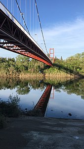
 The American River at Folsom | |
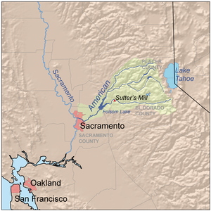
 Map of the American River watershed. It includes the North, Middle, and South forks of the river as well as Rubicon River, a tributary of the Middle Fork. | |
| Location | |
| Country | United States |
| State | California |
| Region | Sacramento Valley |
| City | Sacramento |
| Physical characteristics | |
| Source | North Fork American River |
| • location | Mountain Meadow Lake, Placer County, CA |
| • coordinates | 39°13′04″N 120°16′28″W / 39.21778°N 120.27444°W[1] |
| • elevation | 7,923 ft (2,415 m)[2] |
| 2nd source | South Fork American River |
| • location | Nebelhorn, El Dorado County |
| • coordinates | 38°48′38″N 120°01′52″W / 38.81056°N 120.03111°W[3] |
| • elevation | 7,401 ft (2,256 m)[4] |
| Source confluence | Folsom Lake |
| • location | Near Folsom, California |
| • coordinates | 38°29′28″N 121°09′24″W / 38.49111°N 121.15667°W[5] |
| • elevation | 253 ft (77 m) |
| Mouth | Sacramento River |
• location | Sacramento, CA |
• coordinates | 38°35′51″N 121°30′29″W / 38.59750°N 121.50806°W[5] |
• elevation | 10 ft (3.0 m)[5] |
| Length | 119 mi (192 km), Northeast-southwestMain stem 31 miles (50 km); North Fork 88 miles (142 km)[6] |
| Basin size | 2,150 sq mi (5,600 km2)[7] |
| Discharge | |
| • location | Fair Oaks[8] |
| • average | 3,685 cu ft/s (104.3 m3/s)[8] |
| • minimum | 215 cu ft/s (6.1 m3/s)[8] |
| • maximum | 314,000 cu ft/s (8,900 m3/s)[8] |
| Basin features | |
| River system | Sacramento River watershed |
| Tributaries | |
| • left | South Fork American River |
| • right | North Fork American River |
| Type | Wild, Recreational |
| Designated | November 10, 1978 |


The American River is a 30-mile-long (50 km) river in California that runs from the Sierra Nevada mountain range to its confluence with the Sacramento River in downtown Sacramento. Via the Sacramento River, it is part of the San Francisco Bay watershed. This river is fed by the melting snowpack of the Sierra Nevada and its many headwaters and tributaries, including its North, Middle, and South Forks.
The American River is known for the discovery of gold at Sutter's Mill in Coloma in 1848 that started the California Gold Rush and contributed to the initial large-scale settlement of California by White American migrants. Today, the river still has high quality water, and it is the main source of drinking water for Sacramento.[9] This river is dammed extensively for irrigation, flood control, and hydroelectric power. The American River watershed supports Mediterranean, temperate, and montane ecosystems, and it is the home of a diverse array of fish and wildlife.
- ^ "North Fork American River". Geographic Names Information System. United States Geological Survey, United States Department of the Interior. January 19, 1981. Retrieved September 26, 2010.
- ^ "Mountain Meadow Lake". Geographic Names Information System. United States Geological Survey, United States Department of the Interior. January 19, 1981. Retrieved September 26, 2010.
- ^ "South Fork American River". Geographic Names Information System. United States Geological Survey, United States Department of the Interior. January 19, 1981. Retrieved September 26, 2010.
- ^ "Nebelhorn". Geographic Names Information System. United States Geological Survey, United States Department of the Interior. January 19, 1981. Retrieved September 26, 2010.
- ^ a b c "American River". Geographic Names Information System. United States Geological Survey, United States Department of the Interior. January 19, 1981. Retrieved September 26, 2010.
- ^ U.S. Geological Survey. National Hydrography Dataset high-resolution flowline data. The National Map Archived 2012-03-29 at the Wayback Machine, accessed March 10, 2011
- ^ "Boundary Descriptions and Names of Regions, Subregions, Accounting Units and Cataloging Units". U.S. Geological Survey. Retrieved August 22, 2010.
- ^ a b c d "USGS Gage #11446500 on the American River at Fair Oaks, CA (2009)" (PDF). National Water Information System. United States Geological Survey. Retrieved September 26, 2010.
- ^ "Water Quality". City of Sacramento. Archived from the original on June 2, 2016.