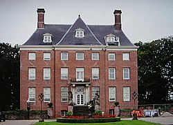
Amerongen | |
|---|---|
 | |
| Coordinates: 52°0′9″N 5°27′39″E / 52.00250°N 5.46083°E | |
| Country | Netherlands |
| Province | Utrecht |
| Municipality | Utrechtse Heuvelrug |
| Area | |
• Total | 29.68 km2 (11.46 sq mi) |
| Elevation | 42 m (138 ft) |
| Population (2021)[1] | |
• Total | 6,985 |
| • Density | 240/km2 (610/sq mi) |
| Time zone | UTC+1 (CET) |
| • Summer (DST) | UTC+2 (CEST) |
| Postal code | 3958[1] |
| Dialing code | 0343 |
Amerongen (Dutch pronunciation: [ˈaːmərɔŋə(n)] ) is a town in the municipality of Utrechtse Heuvelrug in the province of Utrecht, Netherlands, on the border of the Utrecht Hill Ridge. It lies about 7 km (4.3 mi) southwest of Veenendaal (10.5 km or 6.5 mi by road).
The landscape rises from the flat water meadows of the Nederrijn (Lower Rhine) to the Utrecht Hill Ridge ("Utrechtse Heuvelrug"). The highest point in the western Netherlands is located 2 km east of the village. The Amerongense Berg (Amerongen Mountain) has a height of 69 metres above sea level.
- ^ a b c "Kerncijfers wijken en buurten 2021". Central Bureau of Statistics. Retrieved 27 March 2022.
- ^ "Postcodetool for 3958AA". Actueel Hoogtebestand Nederland (in Dutch). Het Waterschapshuis. 24 July 2019. Retrieved 27 March 2022.


