This article needs additional citations for verification. (July 2022) |
Amroha district | |
|---|---|
 Rauza Haz, Shah Abbas Badr-e-Chisti in Amroha | |
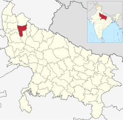
 Location of Amroha district in Uttar Pradesh | |
| Country | |
| State | Uttar Pradesh |
| Division | Moradabad |
| Headquarters | Amroha |
| Government | |
| • Lok Sabha constituency | Amroha |
| Area | |
• Total | 2,321 km2 (896 sq mi) |
| Population (2011) | |
• Total | 1,840,221 |
| • Density | 790/km2 (2,100/sq mi) |
| • Urban | 56% |
| Demographics | |
| • Literacy | 50.21%[1] |
| • Sex ratio | 925 |
| Time zone | UTC+05:30 (IST) |
| Vehicle registration | UP-23 |
| Average annual precipitation | 1,120 mm |
| Website | Official Website |
Amroha is one of the 75 districts of Uttar Pradesh state in northern India.[2] Amroha town is the district headquarters. According to the Government of India, the district is one of the Minority Concentrated Districts on the basis of the 2001 census data on population, socio-economic indicators and basic amenities indicators.[3]
The district is bounded on the north by Bijnor district, on the east and southeast by Moradabad district, on the south by Badaun district, and on the west by the River Ganges, across which lie the Bulandshahr, Hapur, and Meerut districts. State Highways 72 and 73 penetrate the city and act as major routes.
- ^ "District-specific Literates and Literacy Rates, 2001". Registrar General, India, Ministry of Home Affairs. Retrieved 10 October 2010.
- ^ "Important Cabinet Decisions". Lucknow: Information and Public Relations Department. Archived from the original on 24 October 2014. Retrieved 17 January 2013.
- ^ "Press Information Bureau English Releases". Pib.nic.in. Retrieved 13 June 2012.