Native name: Ennepah, 'Anyapakh | |
|---|---|
 Satellite view of Anacapa Island | |
| Etymology | mirage island |
| Geography | |
| Location | Pacific Ocean |
| Archipelago | Northern Channel Islands |
| Adjacent to | Pacific Ocean |
| Major islands | West, Middle, East |
| Area | 699 acres (283 ha) |
| Length | 5 mi (8 km)[1] |
| Width | 0.5 mi (0.8 km)[1] |
| Highest elevation | 930 ft (283 m) |
| Highest point | Vela Peak/Summit Peak 2 |
| Administration | |
United States | |
| State | California |
| County | Ventura |
| Demographics | |
| Population | 3 (2000) |
| Additional information | |
| Official website | http://www.nps.gov/chis/planyourvisit/anacapa.htm |


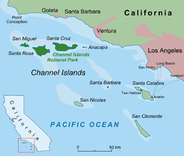
Anacapa Island (Chumash: Anyapax, meaning "mirage, illusion")[2][3][4] is a small volcanic island located about 11 miles (9.6 nmi; 18 km) off Port Hueneme in Ventura County, California. The island is composed of a series of narrow islets 6 mi (10 km) long, oriented generally east–west and 5 mi (8 km) east of Santa Cruz Island. The three main islets, East, Middle and West Anacapa, have precipitous cliffs, dropping off steeply into the sea.
Anacapa is the smallest of the northern islands of the Channel Islands archipelago, and is within the Channel Islands National Park. It is 9 miles (7.8 nmi; 14 km) across the Santa Barbara Channel from the nearest point on the mainland. It lies southwest of the city of Ventura, California.[5] The northern waters of Anacapa Island are protected by the Anacapa State Marine Reserve, which is one of the MPAs existing in the Channel Island National Park.[6][7]
Public passenger access to Anacapa Island is provided by Island Packers ferry service out of either the Ventura Harbor or Channel Islands Harbor in Oxnard, California.
- ^ a b Palmer 2004, p. 763.
- ^ Bright, William (1998). 1500 California Place Names: Their Origin and Meaning. Berkeley, CA: University of California Press.
- ^ Harrington, John P. John P. Harrington's Notes, Reel 68.
- ^ "Chumash Place Names". Archived from the original on 2015-04-01. Retrieved 2017-09-28.
- ^ Anacapa Island Restoration Project. Channel Islands National Park. Final Environmental Impact Statement. Date not stated. Accessed July 21, 2018
- ^ "Anacapa Island State Marine Reserve". California Department of Fish and Wildlife. State of California. Retrieved 11 December 2023.
- ^ "Anacapa island SMR". California Marine Protected Areas. California Marine Protected Areas. Retrieved 11 December 2023.

