| Anatoki River | |
|---|---|
 | |
 Route of the Anatoki River | |
| Location | |
| Country | New Zealand |
| Physical characteristics | |
| Source | |
| • location | Haupiri Range |
| • coordinates | 40°57′23″S 172°32′17″E / 40.9563°S 172.538°E |
| Mouth | |
• location | Tākaka River |
• coordinates | 40°51′40″S 172°47′59″E / 40.8611°S 172.7997°E |
| Basin size | 101 km² |
| Basin features | |
| Progression | Anatoki River → Tākaka River → Golden Bay / Mohua → Tasman Sea |
| Tributaries | |
| • left | Paradise Creek, Handcock Creek, Sheepy Creek |
| • right | Go Ahead Creek |
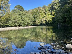
The Anatoki River is a river of New Zealand. It is located in the Tasman Region, and is a tributary of the Tākaka River and is one of the country's steepest rivers.[1] The river's name means cave of stone adzes.[2] The river drains a catchment area of 101 km2 (39 sq mi) that is surrounded by the Haupiri, Douglas, Snowdon, Devil and Anatoki Ranges.[3] Rainfall records in the catchment taken at an elevation of 1,300 m (4,300 ft) show that the 10 year return period storm brings 291 mm (11.5 in) of precipitation in 24 hours.[4]
Anatoki Salmon, a salmon farm and restaurant business, is located adjacent to the Anatoki River.[5]
- ^ "Nelson Region". Jasons Travel Media.
- ^ Wise's New Zealand guide: A gazetteer of New Zealand (4th ed.) (1969) Dunedin: H. Wise & Co. (N.Z.) Ltd.
- ^ "Anatoki at Happy Sams". Tasman District Council. February 2020. Archived from the original on 4 February 2020. Retrieved 21 January 2024.
- ^ "Anatoki at Paradise". Tasman District Council. Retrieved 21 January 2024.
- ^ Mosig, John (July–August 2008). "Salmon farm cultivates tourists" (PDF). New Zealand Aquaculture (24): 6–7.

