Anchor Point, Alaska
K’kaq’ | |
|---|---|
 | |
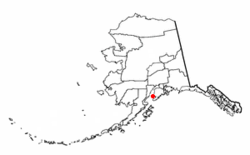
 Location of Anchor Point, Alaska | |
| Coordinates: 59°46′39″N 151°46′13″W / 59.77750°N 151.77028°W | |
| Country | United States |
| State | Alaska |
| Borough | Kenai Peninsula |
| Government | |
| • Borough mayor | Peter Micciche |
| • State senator | Gary Stevens (R) |
| • State rep. | Sarah Vance (R) |
| Area | |
| • Total | 91.76 sq mi (237.66 km2) |
| • Land | 91.65 sq mi (237.36 km2) |
| • Water | 0.12 sq mi (0.30 km2) |
| Elevation | 118 ft (36 m) |
| Population (2020) | |
| • Total | 2,105 |
| • Density | 22.97/sq mi (8.87/km2) |
| Time zone | UTC-9 (Alaska (AKST)) |
| • Summer (DST) | UTC-8 (AKDT) |
| ZIP code | 99556 |
| Area code | 907 |
| FIPS code | 02-03110 |
| GNIS feature ID | 1412516 |
Anchor Point (Dena'ina: K’kaq’) is an unincorporated community and census-designated place (CDP) in Kenai Peninsula Borough, in the U.S. state of Alaska. As of the 2010 census the population was 1,930,[2] up from 1,845 in 2000. The community is located along the Sterling Highway, part of Alaska State Route 1. Anchor Point is the westernmost point in the North American highway system.

- ^ "2020 U.S. Gazetteer Files". United States Census Bureau. Retrieved October 29, 2021.
- ^ "Geographic Identifiers: 2010 Demographic Profile Data (G001): Anchor Point CDP, Alaska". U.S. Census Bureau, American Factfinder. Retrieved January 9, 2019.[dead link]