| Ancrum | |
|---|---|
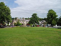
 Village green | |
Location within the Scottish Borders | |
| Population | 500 (2022)[1] |
| OS grid reference | NT625245 |
| • Edinburgh | 38 mi (61 km) NW |
| Civil parish |
|
| Community council |
|
| Council area | |
| Lieutenancy area | |
| Country | Scotland |
| Sovereign state | United Kingdom |
| Post town | JEDBURGH |
| Postcode district | TD8 |
| Dialling code | 01835 |
| Police | Scotland |
| Fire | Scottish |
| Ambulance | Scottish |
| UK Parliament | |
| Scottish Parliament | |
Ancrum (Scottish Gaelic: Alan Crom) is a village in the Borders area of Scotland, 5 km (3.1 mi) northwest of Jedburgh.[2][3]
The village — which currently[when?] has a population of around 300 — is situated just off the A68 trunk road on the B6400, which runs through Ancrum. Lilliesleaf lies 7 miles (11 km) further along the B6400 and Denholm can be reached along the unclassified road which runs parallel to the River Teviot.
The name of this place, anciently Alne-crumb, is derived from the situation of its village on a bend of the River Alne, now the Ale. There were formerly two villages distinguished by the appellations of Over Ancrum and Nether Ancrum, of the former of which nothing now remains.
The principal event of historical importance is the Battle of Ancrum Moor, which originated in an attempt made in 1545, by Ralph Evers and Bryan Layton, to possess themselves of the lands of the Merse and Teviotdale, which had been conferred upon them by a grant of Henry VIII, king of England. Archibald Douglas, 6th Earl of Angus, who had considerable property in that district, determined to resist the attempt, and a battle between his forces and those of the English took place on a moor about a mile and a half north of the village, in which the latter were defeated with great loss. In this conflict, both the villages of Ancrum were burnt to the ground; the village of Nether Ancrum was soon afterwards rebuilt, but of the other nothing remains but the ruins of one or two dilapidated houses.[4]


- ^ "Mid-2020 Population Estimates for Settlements and Localities in Scotland". National Records of Scotland. 31 March 2022. Retrieved 31 March 2022.
- ^ "Zoomable 25 inch OS map with tranparancy slider". National Library of Scotland. OS. Retrieved 3 August 2019.
- ^ "Overview of Ancrum". Gazetteer for Scotland. Retrieved 20 December 2017.
- ^ Lewis 1851, p. 46.
