Andebu Municipality
Andebu kommune | |
|---|---|
| Andebu herred (historic name) | |
 View of the forests and lakes of Andebu seen from Dalaåsen. Credit: Gunnar Gallis | |
|
| |
 Vestfold within Norway | |
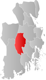
 Andebu within Vestfold | |
| Coordinates: 59°17′50″N 10°6′18″E / 59.29722°N 10.10500°E | |
| Country | Norway |
| County | Vestfold |
| District | Vestfold |
| Established | 1 Jan 1838 |
| • Created as | Formannskapsdistrikt |
| Disestablished | 1 Jan 2017 |
| • Succeeded by | Sandefjord Municipality |
| Administrative centre | Andebu |
| Area (upon dissolution) | |
• Total | 185.90 km2 (71.78 sq mi) |
| • Land | 182.80 km2 (70.58 sq mi) |
| • Water | 3.10 km2 (1.20 sq mi) 1.7% |
| Population (2016) | |
• Total | 5,937 |
| • Density | 32/km2 (83/sq mi) |
| Demonym | Andebusokning[1] |
| Official language | |
| • Norwegian form | Bokmål[2] |
| Time zone | UTC+01:00 (CET) |
| • Summer (DST) | UTC+02:00 (CEST) |
| ISO 3166 code | NO-0719[4] |
Andebu is a former municipality in Vestfold county, Norway. The 186-square-kilometre (72 sq mi) municipality existed from 1838 until its dissolution on 1 January 2017. The area is now part of Sandefjord Municipality. The administrative centre was the village of Andebu. Other main villages in Andebu include Høyjord and Kodal.
Andebu was the fourth-largest municipality in Vestfold county and it was situated in the center of the county. Upon its dissolution, the 186-square-kilometre (72 sq mi) municipality had a population of 5,937. The municipality's population density was 32 inhabitants per square kilometre (83/sq mi).[5][6]
Andebu's economy was primarily related to logging and forestry. Andebu has been inhabited for centuries and the oldest artifacts retrieved here dates back 4000 years to the Iron Age. Most retrieved artifacts are various types of tools, mainly axes made of flint and other rocks. Andebu’s geography consists mainly of valleys, hills, mountains, forests, and lakes.[7]
- ^ "Navn på steder og personer: Innbyggjarnamn" (in Norwegian). Språkrådet.
- ^ "Forskrift om målvedtak i kommunar og fylkeskommunar" (in Norwegian). Lovdata.no. 5 May 2006.
- ^ "Forskrift om målvedtak i kommunar og fylkeskommunar" (in Norwegian). Lovdata.no.
- ^ Bolstad, Erik; Thorsnæs, Geir, eds. (26 January 2023). "Kommunenummer". Store norske leksikon (in Norwegian). Kunnskapsforlaget.
- ^ Statistisk sentralbyrå. "Table: 06913: Population 1 January and population changes during the calendar year (M)" (in Norwegian).
- ^ Statistisk sentralbyrå. "09280: Area of land and fresh water (km²) (M)" (in Norwegian).
- ^ Schandy, Tom; Helgesen, Tom (2012). Naturperler i Vestfold (in Norwegian). Forlaget Tom & Tom v/Schandy. ISBN 9788292916148.: 196

