Andermatt | |
|---|---|
 Andermatt looking west through the Urseren valley towards Hospental in front and the Furka Pass in the back (March 2005) | |
| Coordinates: 46°37′N 8°35′E / 46.617°N 8.583°E | |
| Country | Switzerland |
| Canton | Uri |
| District | n.a. |
| Government | |
| • Executive | Gemeinderat with 5 members |
| • Mayor | Präsidentin Yvonne Baumann |
| • Parliament | none (Offene Dorfgemeinde) |
| Area | |
• Total | 62.26 km2 (24.04 sq mi) |
| Elevation (Church) | 1,437 m (4,715 ft) |
| Highest elevation | 2,999 m (9,839 ft) |
| Lowest elevation (Schöllenen) | 1,289 m (4,229 ft) |
| Population (31 December 2018)[2] | |
• Total | 1,390 |
| • Density | 22/km2 (58/sq mi) |
| Demonym | German: Andermatter(in) |
| Time zone | UTC+01:00 (Central European Time) |
| • Summer (DST) | UTC+02:00 (Central European Summer Time) |
| Postal code(s) | 6490 |
| SFOS number | 1202 |
| ISO 3166 code | CH-UR |
| Localities | Andermatt, Gurschen, Unteralp, Nätschen, Oberalp, Alp Rossboden |
| Surrounded by | Airolo (TI), Göschenen, Gurtnellen, Hospental, Tujetsch (GR) |
| Website | www SFSO statistics |
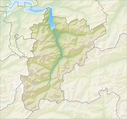
Andermatt (Romansh: ) is a mountain village and municipality in the canton of Uri in Switzerland. At an elevation of 1,437 meters (4,715 ft) above sea level, Andermatt is located at the center of the Saint-Gotthard Massif and the historical center cross of north-south and east-west traverses of Switzerland. It is some 28 km (17 mi) south of Altdorf, the capital of Uri.
- ^ a b "Arealstatistik Standard - Gemeinden nach 4 Hauptbereichen". Federal Statistical Office. Retrieved 13 January 2019.
- ^ https://www.pxweb.bfs.admin.ch/pxweb/fr/px-x-0102020000_201/-/px-x-0102020000_201.px/table/tableViewLayout2/?rxid=c5985c8d-66cd-446c-9a07-d8cc07276160. Retrieved 2 June 2020.
{{cite web}}: Missing or empty|title=(help)


