Anderson County | |
|---|---|
 The Anderson County Courthouse in Palestine | |
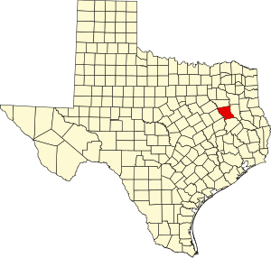
 Location within the U.S. state of Texas | |
 Texas's location within the U.S. | |
| Coordinates: 31°49′N 95°39′W / 31.81°N 95.65°W | |
| Country | |
| State | |
| Founded | March 24, 1846 |
| Named for | Kenneth L. Anderson |
| Seat | Palestine |
| Largest city | Palestine |
| Area | |
• Total | 1,078 sq mi (2,790 km2) |
| • Land | 1,063 sq mi (2,750 km2) |
| • Water | 15 sq mi (40 km2) 1.4% |
| Population (2020) | |
• Total | 57,922 |
| • Density | 54/sq mi (21/km2) |
| Time zone | UTC−6 (Central) |
| • Summer (DST) | UTC−5 (CDT) |
| Congressional district | 6th |
| Website | www |
Anderson County is a county in the U.S. state of Texas. Located within East Texas, its county seat is Palestine.[1] As of the 2020 United States census, the population of Anderson County was 57,922.[2] Anderson County comprises the Palestine micropolitan statistical area. Anderson County was organized in 1846, and was named after Kenneth Lewis Anderson (1805-1845), the last vice president of the Republic of Texas.
- ^ "Find a County". National Association of Counties. Archived from the original on May 31, 2011. Retrieved June 7, 2011.
- ^ "U.S. Census Bureau QuickFacts: Anderson County, Texas". US Census Bureau. Retrieved January 31, 2022.