Andijk | |
|---|---|
Village | |
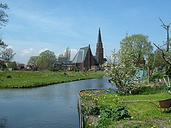
 Church of Andijk | |
| Coordinates: 52°45′N 5°13′E / 52.75°N 5.22°E | |
| Country | Netherlands |
| Province | North Holland |
| Municipality | Medemblik |
| Area | |
• Total | 22.85 km2 (8.82 sq mi) |
| Elevation | −1.3 m (−4.3 ft) |
| Population (2021)[1] | |
• Total | 7,005 |
| • Density | 310/km2 (790/sq mi) |
| Time zone | UTC+1 (CET) |
| • Summer (DST) | UTC+2 (CEST) |
| Postal code | 1619[1] |
| Dialing code | 0228 |
Andijk (Dutch: [ɑnˈdɛik] ; West Frisian: Andìk) is a former municipality and a village bordering Lake IJssel in the Netherlands, in the province of North Holland and the region of West-Frisia. Since 1 January 2011 Andijk has been part of Medemblik municipality.
The name Andijk comes from the Dutch: aan de dijk, lit. 'at the dike'. In 1667 a small church was built. During the Napoleonic occupation, Andijk became an independent municipality on 1 January 1812 by imperial decree of 21 October 1811.
Andijk has fertile clay soil used for agriculture and vegetable horticulture and is also an important supplier of drinking water for the region.
- ^ a b c "Kerncijfers wijken en buurten 2021". Central Bureau of Statistics. Retrieved 1 May 2022.
- ^ "Postcodetool for 1619AA". Actueel Hoogtebestand Nederland (in Dutch). Het Waterschapshuis. Retrieved 1 May 2022.


