Andover, Maine | |
|---|---|
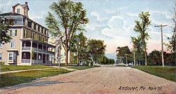
 Main Street c. 1906 | |
| Coordinates: 44°38′3″N 70°45′9″W / 44.63417°N 70.75250°W | |
| Country | United States |
| State | Maine |
| County | Oxford |
| Incorporated | 1804 |
| Area | |
• Total | 57.46 sq mi (148.82 km2) |
| • Land | 57.42 sq mi (148.72 km2) |
| • Water | 0.04 sq mi (0.10 km2) |
| Elevation | 669 ft (204 m) |
| Population | |
• Total | 752 |
| • Density | 14.3/sq mi (5.5/km2) |
| Time zone | UTC-5 (Eastern (EST)) |
| • Summer (DST) | UTC-4 (EDT) |
| ZIP code | 04216 |
| Area code | 207 |
| FIPS code | 23-01325 |
| GNIS feature ID | 0582325 |
Andover is a town in Oxford County, Maine, United States. The population was 752 at the 2020 census. Set among mountains and crossed by the Appalachian Trail, Andover is home to the Lovejoy Covered Bridge and is the site of the Andover Earth Station.


