| Angelina River Shawnee Creek | |
|---|---|
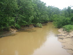
 The muddy Angelina River on Texas State Highway 21 west of Nacogdoches | |
 | |
| Native name | Río Angelina (Spanish) |
| Location | |
| Country | United States |
| State | Texas |
| Physical characteristics | |
| Source | Berryhill Creek |
| • coordinates | 32°01′25″N 94°49′35″W / 32.0234986°N 94.8263255°W[1] |
| Mouth | Neches River |
• location | Pace Hill, Texas, United States |
• coordinates | 30°53′41″N 94°11′52″W / 30.8946441°N 94.1976929°W[1] |
| Length | 120 mi (190 km) |
The Angelina River is formed by the cnfluence of Barnhardt and Shawnee creeks 3 miles (5 km) northwest of Laneville in southwest central Rusk County, Texas, United States.[2]
A tributary of the Neches River, the river flows southeast for 120 miles (193 km) and forms the boundaries between Cherokee and Nacogdoches, Angelina and Nacogdoches, and Angelina and San Augustine counties. It passes under US 59 via former Angelina River Bridge. It empties into the Neches River 12 miles (19 km) north of Jasper in northwestern Jasper County.[3]
The Sam Rayburn Reservoir is on the southern part of the river.