Angera | |
|---|---|
| Città di Angera | |
 | |
| Coordinates: 45°46′N 08°35′E / 45.767°N 8.583°E | |
| Country | Italy |
| Region | Lombardy |
| Province | Varese (VA) |
| Frazioni | Capronno, Barzola |
| Government | |
| • Mayor | Municipal prefect |
| Area | |
| • Total | 17 km2 (7 sq mi) |
| Elevation | 193 m (633 ft) |
| Population (31 December 2011)[2] | |
| • Total | 5,622 |
| • Density | 330/km2 (860/sq mi) |
| Demonym | Angeresi |
| Time zone | UTC+1 (CET) |
| • Summer (DST) | UTC+2 (CEST) |
| Postal code | 21021 |
| Dialing code | 0331 |
| Patron saint | Santa Maria Assunta |
| Saint day | 15 August |
| Official website | |
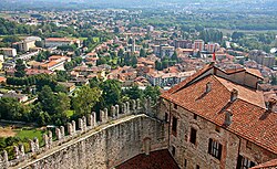
Angera (Italian: [anˈdʒɛːra], Western Lombard: [ãˈdʒeːra]; Latin: Angleria) is a town and comune located in the province of Varese, in the Lombardy region of northern Italy. In Roman times, it was an important lake port and road station. Formerly known as Anghiera, Angera received the title of city from Duke Ludovico il Moro in 1497. The town is situated on the eastern shore of Lago Maggiore.
- ^ "Superficie di Comuni Province e Regioni italiane al 9 ottobre 2011". Italian National Institute of Statistics. Retrieved 16 March 2019.
- ^ "Popolazione Residente al 1° Gennaio 2018". Italian National Institute of Statistics. Retrieved 16 March 2019.


