| Angle Vale South Australia | |||||||||||||||
|---|---|---|---|---|---|---|---|---|---|---|---|---|---|---|---|
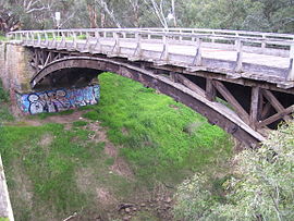
 Angle Vale Bridge | |||||||||||||||
| Coordinates | 34°38′31″S 138°38′49″E / 34.642°S 138.647°E | ||||||||||||||
| Population | 4,088 (UCL 2021)[1] | ||||||||||||||
| Postcode(s) | 5117 | ||||||||||||||
| Location | |||||||||||||||
| LGA(s) | City of Playford | ||||||||||||||
| State electorate(s) | Taylor | ||||||||||||||
| Federal division(s) | Spence | ||||||||||||||
| |||||||||||||||
Angle Vale is a semi-rural town on the Adelaide Plains between Gawler and Virginia in South Australia. It is steadily being surrounded by Adelaide's suburban sprawl. It is close to many vineyards and farms. The town includes Trinity College's Gawler River campus, Angle Vale Primary School and Riverbanks College. Some students travel to nearby towns or to Gawler.
- ^ Australian Bureau of Statistics (28 June 2022). "Angle Vale (urban centre and locality)". Australian Census 2021.
