Anhai
安海镇 | |
|---|---|
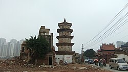
 Surviving White Pagoda (center) of Shuixin Chan Temple (right), with the adjacent old residential neighborhood (left) demolished, to make way for new development (such as seen in the background) | |
| Coordinates (Anhai town government): 24°43′00″N 118°28′34″E / 24.7166°N 118.4761°E | |
| Country | People's Republic of China |
| Province | Fujian |
| Prefecture-level city | Quanzhou |
| County-level city | Jinjiang |
| Time zone | UTC+8 (China Standard) |
| Anhai | |||||||||||||||||||||
|---|---|---|---|---|---|---|---|---|---|---|---|---|---|---|---|---|---|---|---|---|---|
| Chinese | 安海 | ||||||||||||||||||||
| |||||||||||||||||||||
Anhai[a] is a town in southern Fujian province or Minnan, People's Republic of China. It is located in the far southern suburbs of the Quanzhou metropolitan area and is separated by Weitou Bay (simplified Chinese: 围头湾; traditional Chinese: 圍頭灣; Pe̍h-ōe-jī: Ûi-thâu-oân) from Kinmen, which is controlled by the Republic of China on Taiwan. Administratively, Anhai is part of Jinjiang County-level City, which in its turn is subordinated to Quanzhou.
The highest point in the town's administrative area is Mount Língyuán (simplified Chinese: 灵源山; traditional Chinese: 靈源山; Pe̍h-ōe-jī: Lêng-goân-soaⁿ) at 305 metres (1,001 ft).
- ^ 厦门大学中国语言文学研究所汉语方言研究室, ed. (1982). 普通话闽南方言词典 [Dictionary of Putonghua and Min Nan Dialect] (in Chinese). Fuzhou: Fujian People's Publishing House. ISBN 962-04-0228-6.
- ^ Chisholm, Hugh, ed. (1911), , Encyclopædia Britannica, vol. 6 (11th ed.), Cambridge University Press, p. 231
Cite error: There are <ref group=lower-alpha> tags or {{efn}} templates on this page, but the references will not show without a {{reflist|group=lower-alpha}} template or {{notelist}} template (see the help page).
