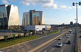
Anjou | |
|---|---|
 | |
 Anjou's location in Montreal | |
| Coordinates: 45°36′24″N 73°33′20″W / 45.60667°N 73.55556°W | |
| Country | |
| Province | |
| City | Montreal |
| Region | Montréal |
| Established | February 23, 1956 |
| Merged into Montreal | January 1, 2002 |
| Electoral Districts Federal | Honoré-Mercier |
| Provincial | Anjou–Louis-Riel |
| Government | |
| • Type | Borough |
| • Mayor | Luis Miranda |
| • Federal MP(s) | Pablo Rodríguez (LPC) |
| • Quebec MNA(s) | Karine Boivin Roy (CAQ) |
| Area | |
| • Land | 13.7 km2 (5.3 sq mi) |
| Population | |
| • Total | 42,796 |
| • Density | 3,128.4/km2 (8,103/sq mi) |
| • Dwellings | 18,810 |
| Time zone | UTC−5 (Eastern (EST)) |
| • Summer (DST) | UTC−4 (EDT) |
| Postal code(s) | |
| Area codes | (514) and (438) |
| Access Routes[5] | |
| Website | www.ville.montreal.qc.ca/anjou |
Anjou (French pronunciation: [ɑ̃ʒu]) is a borough (arrondissement) of the Canadian city of Montreal. Prior to its 2002 merger it was an independent city. Although it is no longer an independent city, it is still commonly known as known as Ville d'Anjou. Anjou has a predominantly Francophone population.[6]
- ^ "Ministère des Affaires Municipales et Régions: Anjou". Archived from the original on 2013-01-06. Retrieved 2012-03-14.
- ^ Parliament of Canada Federal Riding History: HONORÉ-MERCIER (Quebec)
- ^ Chief Electoral Officer of Québec - 40th General Election Riding Results: ANJOU[permanent dead link]
- ^ "Arrondissement d'Anjou" (PDF). Sociodemographic Profile 2016 Census (in French). City of Montreal. May 2018. Archived from the original (PDF) on July 25, 2023.
- ^ Official Transport Quebec Road Map
- ^ Wellington, T. A. (2015-07-13). "My Montreal: Anjou & Other Quebec Curios". montrealrampage.com. Retrieved 2023-07-01.
