| Anmatjere Northern Territory | |||||||||||||||
|---|---|---|---|---|---|---|---|---|---|---|---|---|---|---|---|
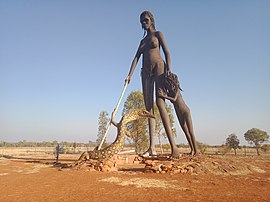
 Sculpture at the Aileron Roadhouse on the Stuart Highway | |||||||||||||||
| Coordinates | 21°44′47″S 133°19′08″E / 21.7463°S 133.319°E[1] | ||||||||||||||
| Population | 477 (2016 census)[2] [a] | ||||||||||||||
| • Density | 0.008758/km2 (0.022684/sq mi) | ||||||||||||||
| Established | 4 April 2007[1] | ||||||||||||||
| Postcode(s) | 0872[3] | ||||||||||||||
| Elevation | 566 m (1,857 ft)(weather station) [4] | ||||||||||||||
| Area | 54,462 km2 (21,027.9 sq mi)[5] | ||||||||||||||
| Time zone | ACST (UTC+9:30) | ||||||||||||||
| Location | 1,088 km (676 mi) S of Darwin City[3] | ||||||||||||||
| LGA(s) | |||||||||||||||
| Territory electorate(s) | Stuart[7] | ||||||||||||||
| Federal division(s) | Lingiari[8] | ||||||||||||||
| |||||||||||||||
| |||||||||||||||
| Footnotes | Adjoining localities[9][10][6] | ||||||||||||||
Anmatjere is a locality in the Northern Territory of Australia located about 1,088 kilometres (676 mi) south of the territory capital of Darwin.[1][3]
- ^ a b c d "Place Names Register Extract for Anmatjere". NT Place Names Register. Northern Territory Government. Retrieved 27 October 2019.
- ^ Australian Bureau of Statistics (27 June 2017). "Anmatjere (State Suburb)". 2016 Census QuickStats. Retrieved 27 October 2019.
- ^ a b c "Anmatjere Postcode". postcode-finders.com.au. Retrieved 27 October 2019.
- ^ a b c d "Monthly climate statistics: Summary statistics Territory Grape Farm (nearest weather station with recent published data)". Commonwealth of Australia, Bureau of Meteorology. Retrieved 27 October 2019.
- ^ "Anmatjere". Australias Guide Pty Ltd. Retrieved 19 January 2020.
- ^ a b "Localities within Central Desert Shire (sic) (map)" (PDF). Northern Territory Government. 2 April 2007. Archived from the original (PDF) on 18 March 2019. Retrieved 27 October 2019.
- ^ "Division of Daly". Northern Territory Electoral Commission. Archived from the original on 20 March 2020. Retrieved 28 October 2019.
- ^ "Profile of the electoral division of Lingiari (NT)". Australian Electoral Commission. Retrieved 28 October 2019.
- ^ "Anmatjere". NT Atlas and Spatial Data Directory. Northern Territory Government. Retrieved 27 October 2019.
- ^ "Localities within Barkly Region (map)" (PDF). Northern Territory Government. 2 April 2007. Archived from the original (PDF) on 18 March 2019. Retrieved 27 October 2019.
Cite error: There are <ref group=lower-alpha> tags or {{efn}} templates on this page, but the references will not show without a {{reflist|group=lower-alpha}} template or {{notelist}} template (see the help page).
