Annandale, Virginia | |
|---|---|
 Suburban Annandale in 2015 | |
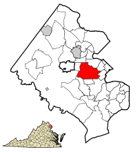
 Location of Annandale in Fairfax County, Virginia | |
| Coordinates: 38°50′3″N 77°12′41″W / 38.83417°N 77.21139°W | |
| Country | |
| State | |
| County | Fairfax |
| Settled | 1685[1] |
| Named for | Annandale, United Kingdom |
| Area | |
• Total | 7.86 sq mi (20.4 km2) |
| • Land | 7.86 sq mi (20.4 km2) |
| • Water | 0.0 sq mi (0.0 km2) |
| Elevation | 361 ft (110 m) |
| Population (2020) | |
• Total | 43,363 |
| • Density | 5,516.9/sq mi (2,130.1/km2) |
| Time zone | UTC−5 (Eastern (EST)) |
| • Summer (DST) | UTC−4 (EDT) |
| ZIP Code | 22003 |
| Area codes | 703, 571 |
| FIPS code | 51-01912[2] |
| GNIS feature ID | 1492474[3] |
| Website | www.annandale.va.us |
Annandale (/ˈænəndeɪl/)[4] is a census-designated place (CDP) in Fairfax County, Virginia.[5] The population of the CDP was 43,363 as of the 2020 United States Census.[2] It is home to the oldest and largest branch of the Northern Virginia Community College system, and to one of the D.C. area's Koreatowns.
- ^ Tom (October 18, 2013). "Why Is It Named Annandale?". Ghosts of D.C. Ghosts of Cities, LLC. Archived from the original on October 29, 2013. Retrieved October 29, 2013.
1685
- ^ a b "U.S. Census website". United States Census Bureau. Retrieved January 29, 2022.
- ^ "US Board on Geographic Names". United States Geological Survey. October 25, 2007. Retrieved January 31, 2008.
- ^ "Annandale". Webster's New World College Dictionary (4th ed.). Houghton Mifflin Harcourt. 2010. Retrieved June 10, 2019.
- ^ "Annandale CDP, Virginia" (Archive). U.S. Census Bureau. Retrieved on April 2, 2015. "2010 CENSUS - CENSUS BLOCK MAP: Annandale CDP, VA"


