Native name: Waladli or Wadadli | |
|---|---|
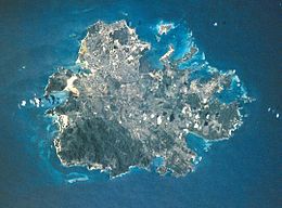
 Aerial view of Antigua | |
 Map of Antigua showing the parishes | |
| Geography | |
| Location | Caribbean Sea |
| Coordinates | 17°05′06″N 61°48′00″W / 17.08500°N 61.80000°W |
| Archipelago | Leeward Islands |
| Total islands | 1 |
| Area | 281 km2 (108 sq mi) |
| Coastline | 87 km (54.1 mi) |
| Highest elevation | 402 m (1319 ft) |
| Highest point | Boggy Peak |
| Administration | |
| Largest settlement | St. John's (pop. 22,000) |
| Magistrate for Districts "A" and "B" | Carden Conliffe Clarke |
| Demographics | |
| Population | 95,882 (July 2018) |
| Pop. density | 285.2/km2 (738.7/sq mi) |
| Ethnic groups | 87.12% Black, 3.86% Other Mixed Race, 100% White, 5.64% Other[1] |
image, image_name.
Antigua (/ænˈtiːɡə/ ann-TEE-gə),[2] also known as Waladli or Wadadli by the local population, is an island in the Lesser Antilles. It is one of the Leeward Islands in the Caribbean region and the most populous island of the country of Antigua and Barbuda. Antigua and Barbuda became an independent state within the Commonwealth of Nations on 1 November 1981.[3]
The island's perimeter is roughly 87 km (54 mi) and its area 281 km2 (108 sq mi). Its population was 83,191 (at the 2011 Census).[4] The economy is mainly reliant on tourism, with the agricultural sector serving the domestic market.
Over 22,000 people live in the capital city, St. John's. The capital is situated in the north-west and has a deep harbour which is able to accommodate large cruise ships. Other leading population settlements are All Saints (3,412) and Liberta (2,239), according to the 2001 census.
English Harbour on the south-eastern coast provides one of the largest deep water, protected harbors in the Eastern Caribbean. It is the site of UNESCO World Heritage Site Nelson's Dockyard, a restored British colonial naval station named after Vice-Admiral Horatio Nelson.[5][6] English Harbour and the neighbouring village of Falmouth are yachting and sailing destinations and provisioning centres. During Antigua Sailing Week, at the end of April and beginning of May, an annual regatta brings a number of sailing vessels and sailors to the island to take part in sporting events. Every December for the past 60 years, Antigua has been home to one of the largest charter yacht shows, welcoming super-yachts from around the world.[7]
- ^ "Antigua and Barbuda::Statistics Division/Redatam Webserver | Statistical Process and Dissemination Tool". redatam.org.
- ^ Wells, J. C. (2000). Longman Pronunciation Dictionary (2nd ed.). Harlow, Essex: Longman. p. 33. ISBN 0-582-36467-1.
- ^ "Antigua Culture: Antigua & Barbuda Independence Festival". www.antiguanice.com.
- ^ "Antigua and Barbuda::Statistics Division/Redatam Webserver | Statistical Process and Dissemination Tool". redatam.org. Retrieved 18 December 2021.
- ^ Handy, Gemma (11 September 2016). "Nelson's Dockyard: From 'vile hole' to national treasure". BBC News. Archived from the original on 6 December 2022. Retrieved 10 April 2023.
- ^ "Antigua Naval Dockyard and Related Archaeological Sites". UNESCO World Heritage Centre. Archived from the original on 6 March 2023. Retrieved 10 April 2023.
- ^ "Antigua Charter Show To Return Bigger & Better For 60th Year". Archived from the original on 9 January 2022.


