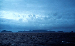
 The Antipodes Islands seen from the north | |
 Position relative to New Zealand and other outlying islands | |
| Geography | |
|---|---|
| Location | 860 km southeast of Stewart Island |
| Coordinates | 49°40′48″S 178°46′48″E / 49.68000°S 178.78000°E |
| Archipelago | Antipodes Islands |
| Major islands | Antipodes, Bollons |
| Area | 21[1] km2 (8.1 sq mi) |
| Highest elevation | 366 m (1201 ft) |
| Highest point | Mount Galloway |
| Administration | |
New Zealand | |
| Demographics | |
| Population | 0[2] (2006) |
| Additional information | |
| Nature reserve | |
The Antipodes Islands (Māori: Moutere Mahue, lit. 'Abandoned Island') are inhospitable and uninhabited volcanic islands in subantarctic waters to the south of – and territorially part of – New Zealand. The 21 km2 (8.1 sq mi) archipelago lies 860 km (530 mi) to the southeast of Stewart Island / Rakiura, and 730 km (450 mi) to the northeast of Campbell Island.[1] They are very close to being the antipodal point of Normandy in France: the city farthest away is Cherbourg-en-Cotentin.
The island group consists of one main island, Antipodes Island, of 20 km2 (7.7 sq mi) area, Bollons Island to the north, and numerous small islets and stacks.
The islands are listed with the New Zealand Outlying Islands. The islands are an immediate part of New Zealand, but not part of any region or district, but instead Area Outside Territorial Authority, like all the other outlying islands except the Solander Islands.
Ecologically, the islands are part of the Antipodes Subantarctic Islands tundra ecoregion. The islands are inscribed on the UNESCO World Heritage List, together with other subantarctic New Zealand islands. The island group is a nature reserve and there is no general public access. They are the southeasternmost point of land in the world outside of Antarctica.
- ^ a b "Antipodes Islands". doc.govt.nz. Retrieved 7 February 2024.
- ^ Final counts – census night and census usually resident populations, and occupied dwellings – Area outside territorial authority Archived 25 May 2010 at the Wayback Machine, 2006 Census, Statistics New Zealand. Retrieved 26 August 2010.