Antlers, Oklahoma
Kuniotubbee (Choctaw) | |
|---|---|
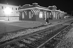
 Antlers historic train station | |
| Nickname: Deer Capital of the World | |
 Location of Antlers, Oklahoma | |
| Coordinates: 34°13′58″N 95°37′23″W / 34.23278°N 95.62306°W | |
| Country | United States |
| State | Oklahoma |
| County | Pushmataha |
| Area | |
| • Total | 3.13 sq mi (8.09 km2) |
| • Land | 3.11 sq mi (8.05 km2) |
| • Water | 0.02 sq mi (0.04 km2) |
| Elevation | 509 ft (155 m) |
| Population (2020) | |
| • Total | 2,221 |
| • Density | 714.38/sq mi (275.86/km2) |
| Time zone | UTC-6 (Central (CST)) |
| • Summer (DST) | UTC-5 (CDT) |
| ZIP code | 74523 |
| Area code | 580 |
| FIPS code | 40-02250[3] |
| GNIS feature ID | 2409716[2] |
Antlers is a city in and the county seat of Pushmataha County, Oklahoma, United States.[4] The population was 2,221 as of the 2020 United States census.[5] The town was named for a kind of tree that becomes festooned with antlers shed by deer, and is taken as a sign of the location of a spring frequented by deer.[6]
- ^ "ArcGIS REST Services Directory". United States Census Bureau. Retrieved September 20, 2022.
- ^ a b U.S. Geological Survey Geographic Names Information System: Antlers, Oklahoma
- ^ "U.S. Census website". United States Census Bureau. Retrieved January 31, 2008.
- ^ "Find a County". National Association of Counties. Archived from the original on May 31, 2011. Retrieved June 7, 2011.
- ^ "Antlers (city), Oklahoma". United States Census Bureau. Retrieved March 16, 2024.
- ^ Wilson, Linda D. Encyclopedia of Oklahoma History and Culture. "Antlers." Retrieved January 9, 2013."Antlers". Archived from the original on September 15, 2009. Retrieved August 30, 2009.