Anzac Avenue | |
|---|---|
 | |
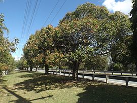
| Mango Trees along Anzac Avenue at Mango Hill, Queensland. | |
 | |
| General information | |
| Type | Road |
| Length | 17.8 km (11 mi) |
| Route number(s) |
|
| Major junctions | |
| West end | |
| |
| East end | |
| Location(s) | |
| Major suburbs | Petrie, Kallangur, North Lakes, Mango Hill, Rothwell, Kippa-Ring, Redcliffe |
| ---- | |
Anzac Avenue is a heritage-listed major arterial road lined with trees in the City of Moreton Bay, Queensland, Australia. It runs 17.8 kilometres (11.1 mi) from Petrie to Redcliffe, with most of the route signed as state route 71. The route was formerly the main route to the Redcliffe peninsula, until the Hornibrook Bridge was opened in 1935.
Opened in 1925, Anzac Memorial Avenue (as it was originally named) is the longest World War I memorial avenue in Queensland and was the first bitumen motor road connecting Brisbane to the popular holiday resort of Redcliffe, and reflects the growth in car usage in the early 1920s. It was added to the Queensland Heritage Register on 5 February 2009.[1]
The road provides the quickest access to the Peninsula Fair Shopping Centre, as well as being the main access road for the Redcliffe Hospital.
- ^ "Anzac Memorial Avenue (former) (entry 602693)". Queensland Heritage Register. Queensland Heritage Council. Retrieved 1 August 2014.