鴨脷洲 | |
|---|---|
 Aerial view of Ap Lei Chau, across Aberdeen Harbour. (2021) | |
 Location of Ap Lei Chau within Hong Kong | |
| Geography | |
| Location | South of Hong Kong Island |
| Coordinates | 22°14′30″N 114°9′20″E / 22.24167°N 114.15556°E |
| Area | 1.3 km2 (0.50 sq mi) |
| Highest elevation | 196 m (643 ft) |
| Highest point | Mount Johnston |
| Administration | |
Hong Kong | |
| District | Southern District |
| Demographics | |
| Population | 79,727 (2021[1]) |
| Pop. density | 61,328/km2 (158839/sq mi) |
| Ap Lei Chau | |||||||||||||||||||
|---|---|---|---|---|---|---|---|---|---|---|---|---|---|---|---|---|---|---|---|
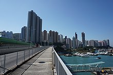
 Ap Lei Chau viewed from Ap Lei Chau Bridge in 2016 | |||||||||||||||||||
| Traditional Chinese | 鴨脷洲 | ||||||||||||||||||
| Simplified Chinese | 鸭脷洲 | ||||||||||||||||||
| Cantonese Yale | Aap-leih-jāu | ||||||||||||||||||
| Literal meaning | Duck-Tongue Island | ||||||||||||||||||
| |||||||||||||||||||
| Former Names | |||||||||
|---|---|---|---|---|---|---|---|---|---|
| Ap Lei San | |||||||||
| Traditional Chinese | 鴨脷山 | ||||||||
| Simplified Chinese | 鸭脷山 | ||||||||
| Literal meaning | Duck-Tongue Island Duck-Tongue Mountain | ||||||||
| |||||||||
| Hong Kong | |||||||||
| Chinese | 香港村 | ||||||||
| Literal meaning | Fragrant Harbour Village | ||||||||
| |||||||||
Ap Lei Chau or Aberdeen Island is an island of Hong Kong, located off Hong Kong Island next to Aberdeen Harbour and Aberdeen Channel. It has an area of 1.30 square kilometres (0.50 sq mi) after land reclamation.[2] Administratively it is part of the Southern District. Ap Lei Chau is one of the most densely populated islands on earth, as well as the most densely populated island with a population of over 10,000.
In the 2000s on their website the Guinness World Records called it the world's most densely populated island.[3]

- ^ "District Profiles". 2021 Population Census.
- ^ Survey and Mapping Office, Lands Department: Hong Kong geographic data sheet
- ^ "History and Society/People & Places/Crowded Island - Most densely populated island". www.guinnessworldrecords.com. Archived from the original on 15 April 2005. Retrieved 2 October 2022.