| Api | |
|---|---|
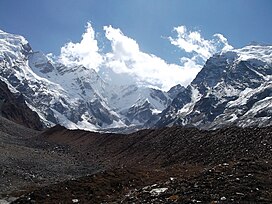
 Approached from the Mahakali Khola, the southern/western aspects of Api. | |
| Highest point | |
| Elevation | 7,132 m (23,399 ft)[1][2] |
| Prominence | 2,040 m (6,690 ft)[1] |
| Listing | Ultras |
| Coordinates | 30°00′15″N 80°56′00″E / 30.00417°N 80.93333°E |
| Geography | |
| Country | Nepal |
| District | Darchula District |
| Parent range | Yoka Pahar Subsection, Gurans Himal, Himalayas |
| Climbing | |
| First ascent | 10 May 1960 by K. Hirabayashi, Gyaltsen Norbu |
| Easiest route | rock/snow/ice climb |

Api is the highest peak in the Yoka Pahar Section of Gurans Himal, part of the Himalayas in the extreme northwest corner of Nepal, near the border with Tibet.[3][failed verification] It is a little-known peak in a rarely visited part of the Himalayas, but it rises dramatically over the low surrounding terrain.[citation needed]

