 | |
| Developer(s) | Apple |
|---|---|
| Initial release | September 19, 2012 |
| Operating system | iOS 6 and later, iPadOS, watchOS, macOS, Safari and Chrome on Mac/iPad, Chrome and Edge on Windows PCs |
| Service name | Apple Maps |
| Available in | 33 languages |
List of languages English, Arabic, Catalan, Croatian, Czech, Danish, Dutch, Finnish, French, German, Greek, Hebrew, Hindi, Hungarian, Indonesian, Italian, Japanese, Korean, Malay, Norwegian Bokmål, Polish, Portuguese, Romanian, Russian, Simplified Chinese, Slovak, Spanish, Swedish, Thai, Traditional Chinese, Turkish, Ukrainian, Vietnamese | |
| Type | Web mapping |
| Website | apple |
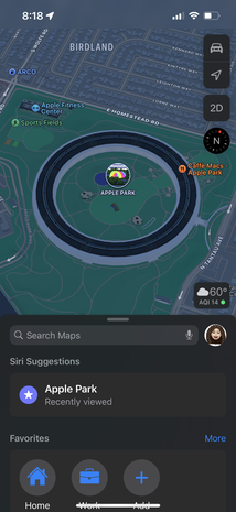
Apple Maps is a web mapping service developed by Apple Inc. As the default map system of iOS, iPadOS, macOS, and watchOS, it provides directions and estimated times of arrival for driving, walking, cycling, and public transportation navigation. A "Flyover" mode shows certain urban centers and other places of interest in a 3D landscape composed of models of buildings and structures.
First released in 2012, Apple Maps replaced Google Maps as the default map system on Apple devices.[1] At launch, it drew criticism from users and reviewers for incorrect directions, sparse data about public transportation, and various other bugs and errors. Apple has since further developed the software to address the issues raised by such criticism.[2]
While formerly exclusive to Apple devices, Apple released a cross-platform MapKit JS API in 2018, allowing Apple Maps to be embedded on the web.[3][4]
- ^ Oreskovic, Alex (April 29, 2013). "Google Now comes to iPhone, challenging Siri". Reuters.
- ^ Barbee, Brie (July 10, 2018). "Apple Maps vs. Google Maps: Which is better at helping you find your way?". Digital Trends. Retrieved October 2, 2018.
- ^ Liao, Shannon (June 6, 2018). "Apple Maps embeds have come to web browsers in beta". The Verge. Retrieved October 31, 2023.
- ^ "Apple Maps on the Web". Apple Developer. Retrieved October 31, 2023.