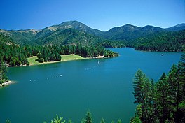
| Applegate Lake | |
|---|---|
 Applegate Lake | |
| Location | Jackson County, Oregon |
| Coordinates | 42°03′17″N 123°06′52″W / 42.05472°N 123.11444°W[1] |
| Type | reservoir, mesotrophic |
| Primary inflows | Applegate River |
| Primary outflows | Applegate River |
| Catchment area | 223 square miles (580 km2) |
| Basin countries | United States |
| Surface area | 988 acres (4.00 km2) |
| Average depth | 83 feet (25 m) |
| Max. depth | 225 ft (69 m) |
| Water volume | 82,200 acre-feet (101,400,000 m3) |
| Residence time | 7 months |
| Shore length1 | 18.5 miles (29.8 km) |
| Surface elevation | 1,985 ft (605 m)[1] |
| References | [2][3] |
| 1 Shore length is not a well-defined measure. | |
Applegate Lake is a 988-acre (400 ha) reservoir located in the Rogue River–Siskiyou National Forest about 27 miles (43 km) southwest of Medford in the U.S. state of Oregon. It is 16 miles (26 km) south of Oregon Route 238 along Applegate River Road and slightly north of the Oregon–California border. The lake is an impoundment of the Applegate River about 46 miles (74 km) from its confluence with the Rogue River.[2]
- ^ a b "Applegate Lake Feature Detail Report". GNIS. USGS. Retrieved 2007-07-31.
- ^ a b Johnson, Daniel M.; Petersen, Richard R.; Lycan, D. Richard; Sweet, James W.; Neuhaus, Mark E.; Schaedel, Andrew L. (1985). Atlas of Oregon Lakes. Corvallis: Oregon State University Press. p. 151. ISBN 0-87071-343-4.
- ^ "Atlas of Oregon Lakes: Applegate Lake (Jackson County)". Portland State University. 1985–2012. Retrieved 2012-07-18.

