| Approuague | |
|---|---|
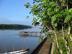
 View of the Approuague from Régina | |
| Location | |
| Country | France |
| Region | French Guiana |
| Physical characteristics | |
| Mouth | Atlantic Ocean |
• coordinates | 4°41′01″N 51°57′41″W / 4.6836°N 51.9613°W |
| Length | 335 km (208 mi) |
The Approuague (French pronunciation: [apʁuaɡ]) river (or Apuruaque in Tupi) is a major river in French Guiana. It is 335 km (208 mi) long.[1] It runs north from the Tumuk Humak Mountains to the Atlantic Ocean, almost parallel with the Oyapock, with its mouth by the Pointe Béhague cape.
The Approuague Bridge is 2 kilometres (1.2 mi) south (upstream) of Régina.
