Ar'arat an-Naqab
| |
|---|---|
| Hebrew transcription(s) | |
| • Also spelled | Ar'ara BaNegev (official) |
 | |
| Coordinates: 31°09′35″N 35°01′25″E / 31.15972°N 35.02361°E | |
| Country | |
| District | Southern |
| Founded | 1982 |
| Government | |
| • Head of Municipality | David Bonfeld (an acting mayor)[1] |
| Area | |
• Total | 14,052 dunams (14.052 km2 or 5.426 sq mi) |
| Population (2022)[2] | |
• Total | 20,381 |
| • Density | 1,500/km2 (3,800/sq mi) |
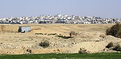
Ar'arat an-Naqab (Arabic: Arabic: عرعرة النقب) or Ar'ara BaNegev (Hebrew: עַרְעָרָה בַּנֶּגֶב), previously called Aroer,[3] is a Bedouin town (local council) in the Southern District of Israel. Its name stands for "the juniper tree[4] in Negev". It is situated not far from the archaeological site of Aroer.[citation needed]
Ar'arat an-Naqab was founded in 1982 as part of a government project to settle Bedouins in permanent settlements. It is one of seven Bedouin townships in the Negev desert with approved plans and developed infrastructure (other six are: Hura, Lakiya, Shaqib al-Salam (Segev Shalom), Kuseife (Kseife), Tel as-Sabi (Tel-Sheva) and the city of Rahat, the largest among them).[5]
- ^ PM Netanyahu meets with Negev Bedouin mayors MFA, November 3, 2011
- ^ "Regional Statistics". Israel Central Bureau of Statistics. Retrieved 21 March 2024.
- ^ Steven C. Dinero (November 2010). Settling for Less: The Planned Resettlement of Israel's Negev Bedouin. Berghahn Books. ISBN 978-1-84545-982-6.
- ^ Palmer, 1881, p.144
- ^ State of Israel. Ministry of Justice, Ministry of Foreign Affairs. List of Issues to be taken up in Connection with the Consideration of Israel's Fourth and Fifth Periodic Reports of Israel (CEDAW/C/ISR/4 and CEDAW/C/ISR/5) Archived 2013-10-15 at the Wayback Machine

