Aragatzotn
Արագածոտն | |
|---|---|
From the top to bottom-right: A Vishap Stone near Lake Kari, Kasakh Gorge, Hovhannavank Monastery, Mount Aragats Alpine Sanctuary, Khachkars in Aragatsotn Province | |
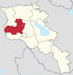
 Location of Aragatzotn within Armenia | |
| Coordinates: 40°25′N 44°10′E / 40.417°N 44.167°E | |
| Country | Armenia |
| Capital and largest city | Ashtarak |
| Government | |
| • Governor | Sergey Movsisyan[2] |
| Area | |
• Total | 2,773 km2 (1,071 sq mi) |
| • Rank | 4th |
| Population (2022) | |
• Total | 128,941[1] |
• Estimate (1 January 2019) | 125,400[3] |
| • Rank | 8th |
| GDP[4] | |
| • Total | ֏ 175.229 billion (US$ 363 million) |
| • Per capita | ֏ 1,371,121 (US$ 2,842) |
| Time zone | AMT (UTC+04) |
| Postal code | 0201-0514 |
| ISO 3166 code | AM.AG |
| FIPS 10-4 | AM01 |
| HDI (2022) | 0.770[5] high · 7th |
| Website | Official website |
Aragatsotn (Armenian: Արագածոտն, Armenian pronunciation: [ɑɾɑɡɑˈt͡sɔtən] ) is a province (marz) of Armenia. It is located in the western part of the country. The capital and largest city of the province is the town of Ashtarak. The Statistical Committee of Armenia reported its population was 128,941 in the 2022 census.[1]
- ^ a b "The Main Results of RA Census 2022, trilingual / Armenian Statistical Service of Republic of Armenia". www.armstat.am. Retrieved 2024-11-07.
- ^ LLC, Helix Consulting. "Government - Regions - The Government of the Republic of Armenia". www.gov.am.
- ^ "Statistical Committee of the Republic of Armenia". armstat.am.
- ^ "Համախառն ներքին արդյունքն (ՀՆԱ) ըստ ՀՀ մարզերի եւ Երեւան քաղաքի 2015-2017թթ" (PDF), armstat.am
- ^ "Sub-national HDI - Area Database - Global Data Lab". hdi.globaldatalab.org. Retrieved 2018-09-13.


