Arapahoe County | |
|---|---|
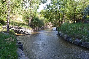
 Little Dry Creek in Englewood | |
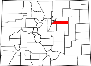
 Location within the U.S. state of Colorado | |
 Colorado's location within the U.S. | |
| Coordinates: 39°38′N 104°20′W / 39.64°N 104.33°W | |
| Country | |
| State | |
| Founded | November 1, 1861 |
| Named for | The Arapaho Nation[2] |
| Seat | Littleton |
| Largest city | Aurora |
| Area | |
• Total | 805 sq mi (2,080 km2) |
| • Land | 798 sq mi (2,070 km2) |
| • Water | 7.3 sq mi (19 km2) 0.9% |
| Population (2020) | |
• Total | 655,070 (3rd)[1] |
| • Density | 821/sq mi (317/km2) |
| Time zone | UTC−7 (Mountain) |
| • Summer (DST) | UTC−6 (MDT) |
| Congressional districts | 1st, 4th, 6th |
| Website | www |
Arapahoe County (/əˈræpəhoʊ/ ə-RAP-ə-hoh) is a county located in the U.S. state of Colorado. As of the 2020 census, its population was 655,070,[1] making it the third-most populous county in Colorado. The county seat is Littleton,[3] and the most populous city is Aurora. The county was named for the Arapaho Native American tribe, who once lived in the region.[2]
Arapahoe County is part of the Denver-Aurora-Lakewood metropolitan statistical area. Arapahoe County calls itself "Colorado's First County", since its origins antedate the Pike's Peak Gold Rush.
- ^ a b "U.S. Census Bureau QuickFacts". U.S. Census Bureau. Retrieved September 4, 2021.
- ^ a b Cite error: The named reference
placenameswas invoked but never defined (see the help page). - ^ "Find a County". National Association of Counties. Archived from the original on May 31, 2011. Retrieved June 7, 2011.
