| Araripe Basin | |
|---|---|
| Bacia do Araripe | |
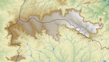
 Geologic map of the Araripe Basin | |
 Outline of the Chapada do Araripe in the basin | |
| Coordinates | 7°23′12″S 40°9′11″W / 7.38667°S 40.15306°W |
| Etymology | Chapada do Araripe |
| Location | South America |
| Region | Northeast |
| Country | |
| State(s) | Ceará, Pernambuco, Piauí |
| Cities | Crato, Ceará |
| Characteristics | |
| On/Offshore | Onshore |
| Boundaries | Patos & Pernambuco lineaments |
| Part of | Brazilian onshore basins |
| Area | ~8,000 km2 (3,100 sq mi) |
| Geology | |
| Basin type | Rift basin |
| Plate | South American |
| Orogeny | Break-up of Gondwana |
| Age | Middle Jurassic-Albian |
| Stratigraphy | Stratigraphy |
The Araripe Basin (Portuguese: Bacia do Araripe) is a rift basin covering about 8,000 square kilometres (3,100 sq mi),[1] in Ceará, Piauí and Pernambuco states of northeastern Brazil. It is bounded by the Patos and Pernambuco lineaments,[2] and is situated east of the Parnaíba Basin, southwest of the Rio do Peixe Basin and northwest of the Tucano and Jatobá Basins.[3]
The basin has provided a variety of unique fossils in the Crato and Santana Formations and includes the Araripe Geopark, a member of the UNESCO Global Geoparks since 2006.[4] The pterosaurs Araripesaurus and Araripedactylus (now considered a nomen dubium), crocodylian Araripesuchus, the turtle Araripemys, amphibian Arariphrynus, the fish Araripelepidotes and the insect Araripenymphes were named after the basin. The bituminous shales of the Ipubi Formation in the Araripe Basin have potential for shale gas development.[5]
- ^ Neto et al., 2013, p.1
- ^ Bianca Carvalho Vieira; André Salgado; Leonardo Santos (2015-03-05). Landscapes and Landforms of Brazil. Springer. p. 232. ISBN 9789401780230.
- ^ Assine, 1992, p.290
- ^ (in Portuguese) Chapada do Araripe vira parque geológico
- ^ Neto et al., 2013, p.3
