Arbutus Ridge | |
|---|---|
Neighbourhood | |
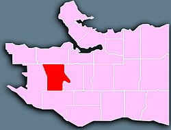
 Location of Arbutus Ridge in Vancouver | |
| Country | |
| Province | |
| Area | |
• Total | 3.7 km2 (1.4 sq mi) |
| Population | |
• Total | 15,295 |
| • Density | 4,133.7/km2 (10,706/sq mi) |
Arbutus Ridge is an affluent residential neighbourhood in Vancouver's West Side. It is bordered by 16th Avenue in the north, 41st Avenue in the south, Mackenzie Street in the west, and East Boulevard in the east. The neighbourhood is characterized by larger than average lot sizes, with stately homes on tree-lined streets.

One of the catalysts for growth in the neighbourhood was the existence of the Vancouver-Steveston Interurban route of the British Columbia Electric Railway, which ran between 1905 and 1958. The route once followed by the interurban is now part of the Arbutus Greenway.
- ^ "Arbutus Ridge; Community Profiles" (PDF). vancouver.ca. Government of the City of Vancouver. Retrieved 12 March 2020.
- ^ "Arbutus Ridge; Community Profiles" (PDF). vancouver.ca. Government of the City of Vancouver. Retrieved 12 March 2020.