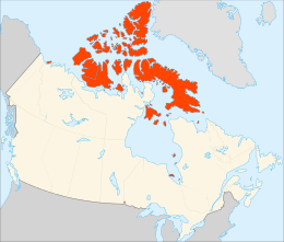
 Polar projection map of the Arctic Archipelago | |
 | |
| Geography | |
|---|---|
| Location | Northern Canada |
| Coordinates | 75°N 90°W / 75°N 90°W |
| Total islands | 36,563 |
| Major islands | Baffin Island, Victoria Island, Ellesmere Island |
| Area | 1,407,770[1] km2 (543,540 sq mi) |
| Administration | |
Canada | |
| Territories and province | Nunavut Northwest Territories Yukon Newfoundland and Labrador |
| Largest settlement | Iqaluit, Nunavut (pop. 7,429[2]) |
| Demographics | |
| Population | 23,073 (2021[2][3]) |
| Pop. density | 0.0098/km2 (0.0254/sq mi) |
The Arctic Archipelago, also known as the Canadian Arctic Archipelago, is an archipelago lying to the north of the Canadian continental mainland, excluding Greenland (an autonomous territory of Denmark) and Iceland (an independent country).
Situated in the northern extremity of North America and covering about 1,424,500 km2 (550,000 sq mi), this group of 36,563 islands, surrounded by the Arctic Ocean, comprises much of Northern Canada, predominately Nunavut and the Northwest Territories.[4] The archipelago is showing some effects of climate change,[5][6] with some computer estimates determining that melting there will contribute 3.5 cm (1.4 in) to the rise in sea levels by 2100.[7]
- ^ "Atlas of Canada – Sea Islands". Atlas.nrcan.gc.ca. 12 August 2009. Archived from the original on 22 January 2013. Retrieved 12 May 2019.
- ^ a b Cite error: The named reference
2021censusNUwas invoked but never defined (see the help page). - ^ Cite error: The named reference
2021censusNWTwas invoked but never defined (see the help page). - ^ Marsh, James H., ed. 1988. "Arctic Archipelago" The Canadian Encyclopedia. Toronto: Hurtig Publishers.
- ^ Thinning of the Arctic Sea-Ice Cover
- ^ Arctic sea ice decline: Faster than forecast
- ^ Wayman, Erin. "Canada's ice shrinking rapidly". Science News.