Arghākhā̃chī District
अर्घाखाँची जिल्ला | |
|---|---|
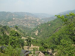
 Valley in Arghakhanchi district | |
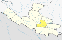
 Location of Arghakhanchi (dark yellow) in Lumbini Province | |
| Country | |
| Province | Lumbini Province |
| Admin HQ. | Sandhikharka |
| Government | |
| • Type | Coordination committee |
| • Body | DCC, Arghākhānchī |
| Area | |
| • Total | 1,199 km2 (463 sq mi) |
| • Rank | 077 |
| Population (2011)[1] | |
| • Total | 197,632 |
| • Density | 160/km2 (430/sq mi) |
| Time zone | UTC+05:45 (NPT) |
| Main Language(s) | Nepali |
| Website | daoarghakhanchi |
Arghakhanchi (Nepali: अर्घाखाँची जिल्ला [ʌɾɡakʰãt͡si] ) is one of the districts of Lumbini Province in Nepal. The district headquarter is Sandhikharka. The district covers an area of 1,193 km2 (461 sq mi) and has a population (2011) of 197,632.[1] Its neighboring districts are Palpa in the east, Gulmi in the north, Kapilvastu District in the south and Pyuthan in the west. The district also covers 4.18 km of road connecting Kapilvastu and Bhalubang, Lalmatiya, Dang with Rapti River as Mahendra Highway or Easy-West Highway.
- ^ a b "National Population and Housing Census 2011(National Report)" (PDF). Central Bureau of Statistics. Government of Nepal. November 3, 2012. Archived from the original (PDF) on May 25, 2013. Retrieved November 3, 2012.