| Argus Range | |
|---|---|
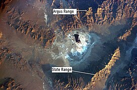
 Argus Range, near Searles Dry Lake, Mojave Desert, California | |
| Highest point | |
| Peak | Maturango Peak |
| Elevation | 8,843 ft (2,695 m) |
| Coordinates | 36°07′14″N 117°29′44″W / 36.1205003°N 117.4956184°W |
| Geography | |
Location of Argus Range in California[1] | |
| Country | United States |
| State | California |
| District | Inyo County |
| Range coordinates | 36°5′8.804″N 117°28′6.223″W / 36.08577889°N 117.46839528°W |
| Topo map | USGS Maturango Peak |
The Argus Range is a mountain range located in Inyo County, California, southeast of the town of Darwin. The range forms the western boundary of Panamint Valley, and the northwestern boundary of Searles Valley. The Coso Range is located to the west, and the Panamint Range to the east.
- ^ "Argus Range". Geographic Names Information System. United States Geological Survey, United States Department of the Interior. Retrieved 2009-05-04.
