| Arizona's 2nd congressional district | |
|---|---|
Interactive map of district boundaries since January 3, 2023 | |
| Representative | |
| Area | 58,970 sq mi (152,700 km2) |
| Distribution |
|
| Population (2023) | 833,298[1] |
| Median household income | $63,735[1] |
| Ethnicity |
|
| Cook PVI | R+6[2] |
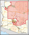
Arizona's 2nd congressional district is a congressional district located in the U.S. state of Arizona. The district is in the north eastern part of the state and includes Apache, Coconino, Gila, Navajo, and Yavapai counties in their entirety and portions of Graham, Maricopa, Mohave, and Pinal counties. The largest city in the district is Flagstaff.
Before January 2023, Arizona's 2nd district was located in the southeastern corner of the state and included Cochise and eastern Pima counties, drawing most of its population from the city of Tucson. The majority of that district was renumbered as the 6th district, while the 2nd was redrawn to essentially take over what was the 1st district from 2003 to 2023.
The district includes 12 Indian reservations including the Hualapai, Havasupai, Hopi, Navajo, San Carlos Apache, and White Mountain Apache peoples. 22% of the district's citizens are Native American.[3]
- ^ a b "My Congressional District". www.census.gov. US Census Bureau. Retrieved September 21, 2024.
- ^ "2022 Cook PVI: District Map and List". Cook Political Report. Retrieved January 10, 2023.
- ^ https://redistricting-irc-az.hub.arcgis.com/pages/final-draft-maps#finalcddraftmaps

