Arkansas River Valley | |
|---|---|
Region | |
 The River Valley as seen from atop Petit Jean Mountain in Petit Jean State Park | |
| Etymology: The Arkansas River | |
 | |
| Coordinates: 35°22′N 93°22′W / 35.36°N 93.37°W | |
| Country | United States |
| State | Arkansas |
| Time zone | UTC−6 (CST) |
| • Summer (DST) | UTC−5 (CDT) |
| Area codes | 479, 501 |
| Part of a series on |
| Regions of Arkansas |
|---|
 |
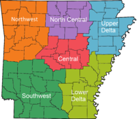
The Arkansas River Valley, also known as the Arkansas Valley, is a region in Arkansas defined by the Arkansas River in the western part of the state. Generally defined as the area between the Ozark and Ouachita Mountains,[1] the River Valley is characterized by flat lowlands covered in fertile farmland and lakes periodically interrupted by high peaks. Mount Magazine, Mount Nebo, and Petit Jean Mountain compose the Tri-Peaks Region, a further subdivision of the River Valley popular with hikers and outdoors enthusiasts. In addition to the outdoor recreational activities available to residents and visitors of the region, the River Valley contains Arkansas's wine country as well as hundreds of historical sites throughout the area. It is one of six natural divisions of Arkansas.[2]
- ^ Arkansas Tour Guide. Arkansas Department of Parks and Tourism. 2013. p. 142.
- ^ Arkansas Tour Guide. Arkansas Department of Parks and Tourism. 2013. p. 141.